
Niobrara River
Discover what makes the Niobrara a must-see destination in the United States.
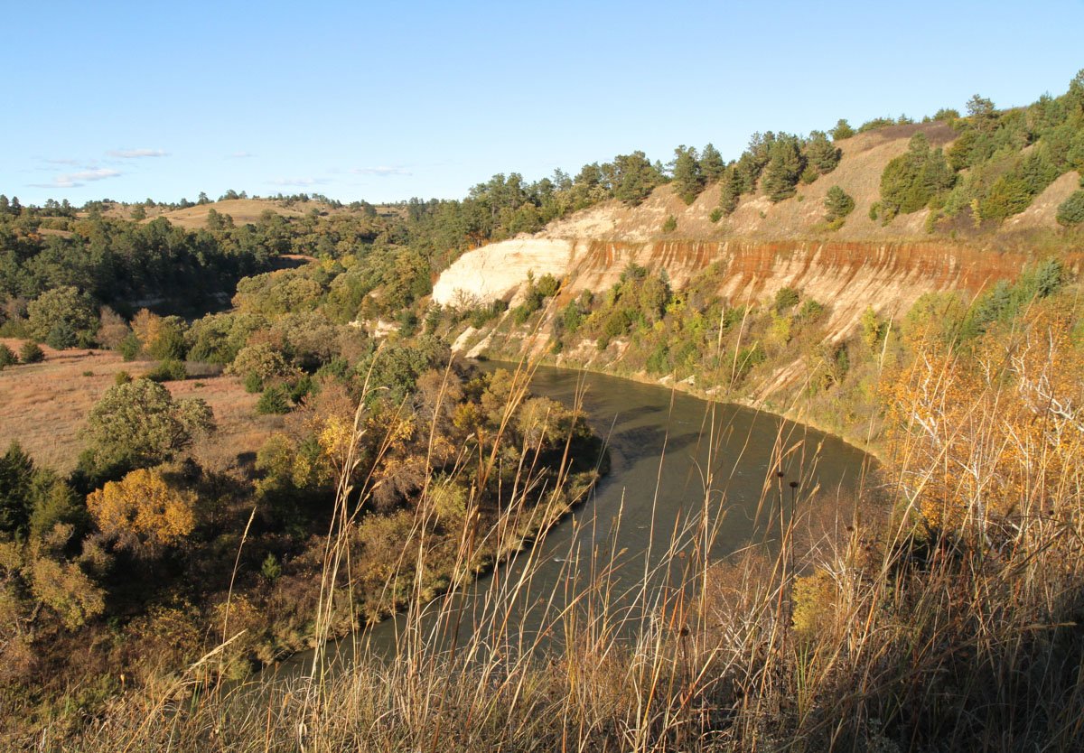
The Niobrara is a remarkable river. From its headwaters in eastern Wyoming to its confluence with the Missouri in northeast Nebraska, it flows over 500 miles across northern Nebraska, its physical character ever changing. However, it is most distinctive along the 50 or so miles running east from Valentine, Nebraska.
Here the Nebraska Sandhills form the southern border of the valley, while harder-soiled tablelands lie to the north. Into these tablelands side-canyons cut miles to the north, their slopes studded with eastern red-cedar and ponderosa pine. This western species of pine reaches its eastern-most distribution in North America along the Niobrara. Other species of the western coniferous forest reach the eastern limits of their distribution along this unusual river. But the south side of the river is where species richness is greatest.

Here, numerous species of the eastern deciduous forest and northern boreal forest can be found in the relatively short “spring-branch” canyons. These narrow canyons are well-watered from the Ogallala Aquifer, and are wooded and protected from the dry south winds, thus creating unique moist, cool microclimates.
Here are mosses and liverworts, sedges and ferns, paper birch and a hybrid aspen. The latter two are considered relicts of the last glacial period, their primary distribution lying far to the north. Birds and other wildlife characteristic of the eastern U.S. live here, including whip-poor-wills, scarlet tanagers and black-and-white warblers. Species-specific bird information can found at Nebraska Birds.
Several species have made a come-back, after decades of absence or scarcity. Elk, river otters, trumpeter swans, and bald eagles may now be encountered along the river. Mountain lion tracks may even be seen.

Lying in the heart of the Great Plains, prairie environments lie adjacent to the valley: northern mixed-grass prairie to the north, Sandhills prairie to the south, and isolated patches of Tallgrass prairie, their roots extending deep into the water table, on the river’s floodplain. Because of this unique blending, and sometimes hybridization, of species characteristic of six different ecosystems, this portion of the Niobrara is known as the “biological crossroads of the Great Plains.”
Needless to say, the admixture of plant communities, as viewed from the river, or from high on the slopes of this deep valley, combined with dramatic, ochre-colored cliffs and numerous waterfalls results in a stunning scenery. From the loosening of winter’s white, through the varied greens of summer, and into the warm hues of autumn, the visual landscape it without peer in Nebraska.
Any season is a treat for the appreciative eye. A float or hike along the riverbanks reveals a multitude of life, including a wide variety of wildflowers and other interesting plants. A rich community of breeding birds provides a morning serenade, while gurgling waters and whispering pines sooth the soul and clear the mind.

How did this remarkable valley come to be? The unique biology and scenery of the Niobrara River valley has its explanation and origins in the geologic formations that were laid down many millions of years ago.
Deepest and oldest is the Pierre Shale, exposed at lower elevations of the eastern portion of the Niobrara National Scenic River. On top of that, and exposed as dramatic cliffs beginning east of Valentine, is the Rosebud Formation, a tannish-pink siltstone. It was deposited by fresh-water streams draining east from the young Rocky Mountains about 28-24 million years ago.
Above the Rosebud is the Valentine Formation. It is 14-12 million years old, and consists mostly of unconsolidated alluvial sands, and ash from volcanic eruptions far to the west. The highest formation (visible on the north side of the river valley) is the 11-6-million-year-old Ash Hollow Formation, including the “cap-rock” that erodes into small cliffs and overhangs.
The Nebraska Sandhills, the largest stabilized dune formation in the Western Hemisphere, developed on top of the exposed Valentine and Ash Hallow Formations on the south side of the river valley. These dunes were shaped and reshaped by strong winds beginning at the end of the last glacial period, about 8-10,000 years ago, and are now mostly stabilized by grass.
Because of the unconsolidated nature of the Sandhills, precipitation penetrates and contributes to the immense Ogallala Aquifer. Where this rapidly eroding (in a geologic sense) river valley has cut below the contact line between the Valentine Formation and the relatively impermeable Rosebud formation, along the south side of the valley, the aquifer’s water seeps out and down the face of the Rosebud cliffs.
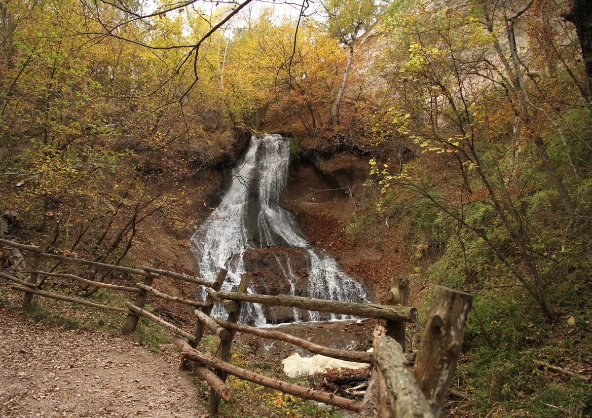
In other areas, the water comes together to form cold-water creeks in the bottom of spring-branch canyons. It is this unique combination of geology and hydrology that has resulted in the cool, moist microclimates in which ice-age relict species exist, and that contributes so much to the great biological richness that characterizes this area.
An added bonus is over 200 waterfalls, some hidden within the spring-branch canyons and others exposed to view from the river. The waterfalls themselves are unusual; they often project outward from a recessed wall on either side. Smith Falls, the highest in Nebraska at over 65-feet, well exemplifies this unique physical characteristic.
This area’s special natural character has been recognized for many decades.
In the early 1900s, a former military fort was converted to the Fort Niobrara National Wildlife Refuge, just a few miles east of Valentine.
In the 1980s, The Nature Conservancy established the 54,000-acre Niobrara Valley Preserve just downriver.
In 1991, the 76 river-miles east of Valentine was designated the Niobrara National Scenic River; it is managed by the National Park Service.
State managed natural areas also dot the Niobrara valley, including Smith Falls State Park, caretaker of the highest waterfall in Nebraska.
The remainder of the middle Niobrara River valley is mostly privately owned, managed as ranches and farms, but also with a number of campgrounds and outfitters catering to visitors wishing to float the river’s mostly languid, but sometimes turbulent, waters. Canoes, kayaks and inner tubes are available for rent, and shuttle services are provided. The Niobrara National Scenic River maintains a list of outfitters that serve the area.